We also estimate fault slip rates in southern California using the pre- and post-Landers geodetic velocities and elastic dislocation theory. We used a modified fault model, defined by the California Department of Mine and Geology (CDMG) (USGS Open-file Report 96-706) and derived mainly from geological information, to lay out the fault geometry. We adopt the CDMG fault slip rates and uncertainties as a priori data to constrain the least-squares inversion of geodetic data for fault slip rates. Generally the geodetic and geologic estimates are consistent, except at a few places. For example, the pre-Landers geodetic rates (21, 6, and 18 mm/yr) are significantly lower than the geologic rates (30, 24, and 25 mm/yr) along the Mojave, San Bernardino, and Coachella Valley sections of the San Andreas, but the other way round at the Brawley Seismic Zone (33 vs 25 mm/yr) and the Imperial Fault (39 vs 20 mm/yr). These discrepancies suggest that the current fault slip rate beneath the locking depth along the San Andreas is lower than its long-term average. This may reflect the fact that the San Andreas has experienced n large earthquake since 1857, and the fault has passed the time period of rapid post-seismic deformation and entered one of slow deformation. However, the discrepancies could also be caused by inadequate modeling deformation around a pinched fault step using thick-skinned dislocation model. The discrepancies at the Landers and Imperial faults are still being affected by post-seismic deformation caused by the 1992 Landers and the 1940 and 1971 Imperial Valley earthquakes, respectively.
A second inversion of the geodetic velocities derived from the post-Landers data reveals a substantial reduction of the fault slip rate along the Mojave section of the San Andreas (21 -> 11 mm/yr) and a significant increase of the fault slip rate along the East San Bernardino Mountains (6 -> 10 mm/yr) respectively. Because the changes in fault slip rates are believed to be caused by the loading stress change along faults, this finding independently confirms the fault responses to the Coulomb stress change after the Landers earthquake (e.g. King et al., BSSA, 1994).
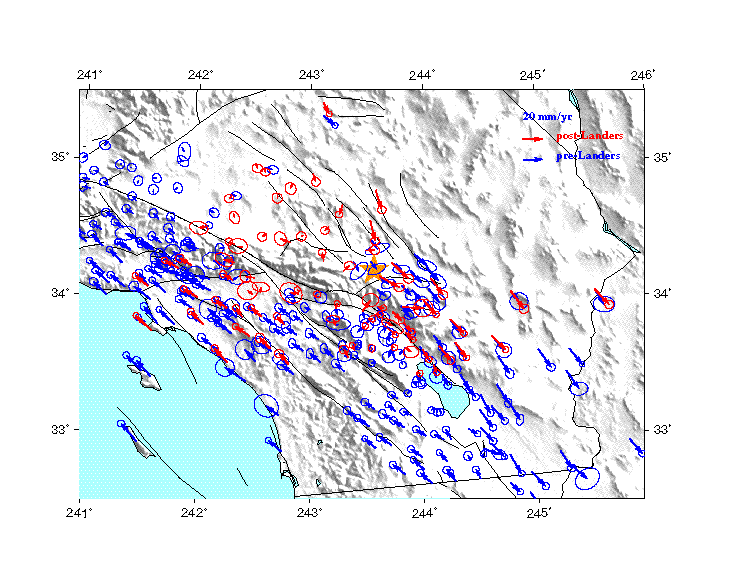
Fig. 1. GPS station velocities before and after Landers earthquake, represented by blue and red arrows respectively. All the station velocities are with respect to half of the Pacific/North America relative plate motion. Error ellipses represent 95% confidence.
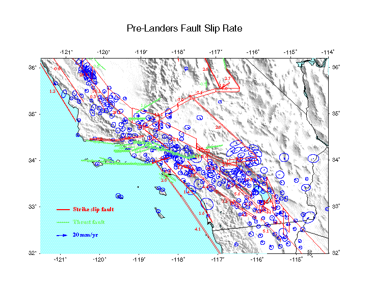
Fig. 2. CDMG fault model inversion result using pre-Landers geodetic data. Red and green patches are the surface projections of the strike slip and thrust fault faults respectively. The height of each fault patch is proportional to its slip rate, whose value is also indicated next to the fault patch. The blue arrows are the post-fit residuals of the station velocities. The predicted station velocities are from inversion using dislocation modeling of the fault slip below locking depth.
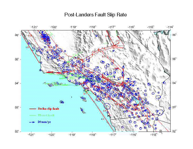
Fig. 3. CDMG fault model inversion result using post-Landers geodetic data. Notions are the same as above except the input data.