Southern California Crustal Deformation Velocity Map
Z.-K. Shen, Y. Bock, D. Dong, T. Herring, K. Hudnut, D. Jackson, R. King,
S. McClusky, and M. Wang
A major goal of the Southern California Earthquake Center (SCEC) is to
map the crustal deformation field and relate it to regional seismic
potential. The deformation field has been released and revised
(
SCEC velocity Map v2.0 release) and another update is underway. In
the current update we include all the important geodetic measurements
collected in southern California during the past 30 years and available
to us, including electronic distance meter (EDM), very long interferometry
baseline (VLBI), and global positioning system (GPS) data. Although the
EDM and VLBI data have longer observational histories, the largest
contribution, in terms of the spatial coverage and precision of the
derived station velocities, comes from GPS measurements. Data from both
the survey mode and permanent (SCIGN) GPS networks are processed together
uniformly, and station velocities and coseismic displacements are derived
in a global reference frame. Stations whose post-seismic velocities may
have been perturbed by the Landers earthquake are allowed to have
different secular velocities before and after the earthquake. All
together the network has about 400 stations covering most of the major
faults in southern California, with their horizontal station velocity
uncertainties < 4 mm/yr. About 2/3 of the sites have their uncertainties
< 2 mm/yr. We are in a process finalizing the results, which will be
released as the SCEC crustal deformation velocity map 3.0.
Fig. 1.
Preliminary result of the velocity map 3.0, each arrow
starts from station location and points to its motion direction. Error
ellipses represent 95% confidence. The red vectors are station velocities
which probably have been affected significantly by post-Landers deformation.
The blue ones are otherwise. All the station velocities are with respect
to half of the North America/Pacific plate relative motion. Stars show
the epicentral locations of earthquakes whose coseismic effects are modeled.
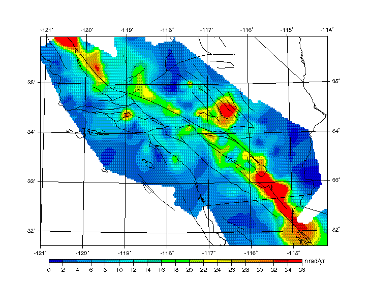
Fig. 2.
Maximum horizontal shear strain rates in
southern California, derived from the velocity solution. The high strain
rates concentrate mainly around surface ruptures of significant earthquakes
occurred in recent history, such as the 1992 Landers, 1952 Kern County, 1940
and 1971 Imperial Valley, and 1857 San Andreas earthquakes.
References:
Shen et al., Southern California geodetic crustal deformation (abstract), EOS,
Am. Geophys. Union, Fall Meeting Suppliment, 80, F267, 1999.